The record
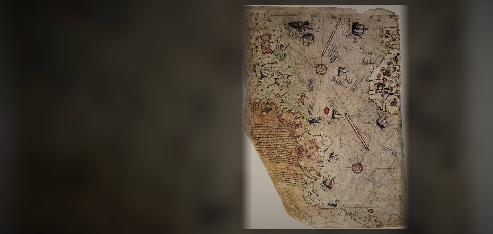
What the map shows. The map is a surviving piece of a larger world map, drawn in ink and watercolor on gazelle skin and measuring 87 by 63 centimeters. It shows the Atlantic with the coasts of Spain and West Africa on one side and the Caribbean and South America on the other. A note in the margin dates it: This map was drawn by Piri Ibn Haji Mehmed, known as the nephew of Kemal Reis, in Gallipoli, in the month of muharrem of the year 919
, that is, between 9 March and 7 April 1513. Another note lists what he worked from: From about twenty charts and Mappae Mundi
, among them one Arabic map of Hind
, the maps just drawn by four Portuguese
and a map drawn by Colombus in the western region
. Of the Caribbean he writes: The coasts and islands on this map are taken from Colombo's map.
No map by Columbus himself of those lands has been found, which is why scholars took notice when Paul Kahle reported the map to the Congress of Orientalists at Leiden in September 1931.
What was claimed. Near the bottom, the coast turns east, and a note says of that land: This country is a waste. Everything is in ruin and, it is said that large snakes are found here.
Captain Arlington Mallery, an engineer and student of old maps, said in a 1956 radio discussion that this coast was Antarctica, mapped when it was free of ice. The college teacher Charles Hapgood and his students worked on the idea for years and published it in Maps of the Ancient Sea Kings in 1966. Hapgood printed a 6 July 1960 letter from Lt. Col. Harold Z. Ohlmeyer of a US Air Force mapping squadron, who wrote that the Antarctic reading was the most logical and in all probability the correct interpretation of the map
and that the coastline had been mapped before it was covered by the ice cap.
Hapgood concluded that a civilization unknown to archaeology had mapped the world in the Ice Age. Two years later Erich von Däniken's best-seller Chariots of the Gods repeated it.
What the record shows. Piri Reis named his own sources: recent Portuguese and Spanish charts and older world maps. The same note on the southern land says it is said to be very hot.
Many of the map's names are, as a 1980 study of the claim put it, clearly transliterations of Portuguese and Spanish.
The historian Gregory McIntosh, who in 2000 published translations of every inscription, traced the Caribbean to Columbus's Second Voyage of 1493 to 1496. The Ohlmeyer letter was one squadron commander's reply to Hapgood's request, printed in Hapgood's own book. Geologists date the start of the Antarctic ice sheet to about 34 million years ago, and a 2024 study in Science found that the first lasting ice formed in East Antarctica, the side that holds Queen Maud Land.